Devpost
Participate in our public hackathons
Devpost for Teams
Access your company's private hackathons
Grow your developer ecosystem and promote your platform
Drive innovation, collaboration, and retention within your organization
By use case
Blog
Insights into hackathon planning and participation
Customer stories
Inspiration from peers and other industry leaders
Planning guides
Best practices for planning online and in-person hackathons
Webinars & events
Upcoming events and on-demand recordings
Help desk
Common questions and support documentation
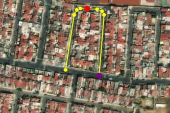
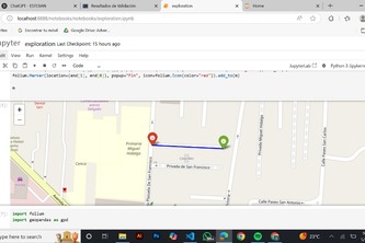
Using a set of points of interests (POI) with their corresponding route as a link of nodes. A trained convolutional neural network on satellite images identifies non-existent or misplaced POI.
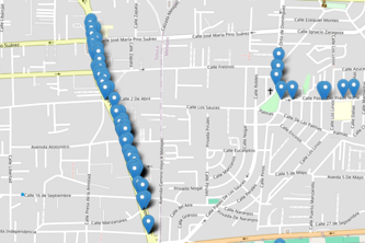
Precision is everything. GeoFix295 validates 190K POIs in Mexico City, fixing +1000 violations with R-tree indexing. Automates corrections, maps per-tile results, ensuring HERE’s maps are accurate.
Pitch jacarandas
We worked with HERE to improve POI accuracy, fixing errors where places were linked to wrong roads or outdated map segments in cities like Mexico City.
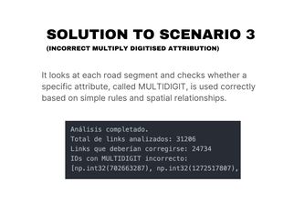
Program to validate a GIS dataset for incorrect placements of "Points of Interest" in Multiply-Digitised Roads
An updated map is the man's new best friend
Classification proposal for HERE Technologies problematic via satellite view and interpolation-geometry analysis.
Validates and corrects POI locations near complex roads using HERE data, satellite imagery, and YOLO detection—automating map cleanup with geospatial analysis and AI.
This is an approximation solution on the problem HERE to solve
POI Verifier ensures accurate Points of Interest (POI) on multiply digitized roads using logical analysis, identifying non-existent POIs, incorrect locations, or attribution errors.
https://github.com/JesusWor/HackatonGDLHere
Our solution analyzes and corrects spatial errors in road data automatically, improving map accuracy and reliability for HERE’s navigation and location services.
VSCuates automates street-side and multidigit validation in dense cities using spatial analysis, speeding up map QA and improving navigation data quality for HERE.
Our main idea was to create a data validation system that detects and fags errors in POI datasets using three key filters, error like non-existence or an incorrect poi location or road interpretation
A rule-based system that automatically detects and classifies spatial errors in POIs using geometric analysis and OpenStreetMap validation, improving the accuracy and reliability of urban data.
The project focuses on automating quality assurance for Points of Interest (POI) data by validating their positional accuracy and attributes against HERE’s street network and satellite imagery
Hackaton
This project aims to identify and correct potential mapping errors through the analysis and integration of geospatial datasets.
Our project identifies POIs in the provided dataset that are related to a multidigit street, and outputs the recommend actions with each one according to the case they match using AI.
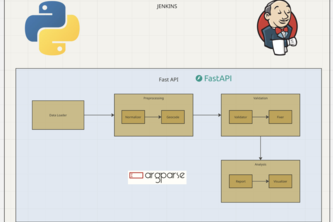
An end-to-end automated pipeline for POI data validation and correction, with real-time logging, emergency control, and transparent reporting, ready for enterprise-scale deployment.
We will use geometric analysis to determine whether the map presents an anomaly.
Using provided data, this project consists in the identification of Points of Interest that present issues in any map at a global level, and automatically fixes errors for correct map data display.
UNDEFINED
1 – 23 of 23